
Introduction to Land GI Viewer Tamil Nadu
Tamil Nadu Land Gi Viewer Online ( Nilam ) In today’s digital age, Tamil Nadu has embraced technology to make land records easily accessible to the public. The Land GI Viewer is an online tool provided by the Tamil Nadu government that allows users to view detailed land information, survey maps, and ownership details from the comfort of their home. This system is especially useful for landowners, buyers, legal professionals, and anyone interested in real estate in Tamil Nadu.
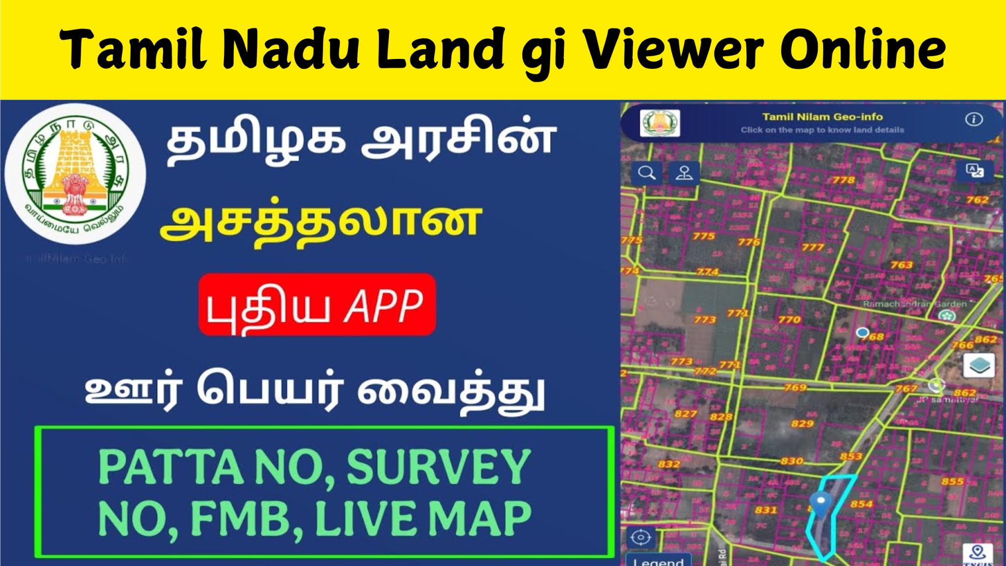
What is the Tamil Nadu Land GI Viewer
The Land GI (Geographical Information) Viewer is an interactive map-based platform that enables citizens to locate land parcels using various parameters like survey number, district, village, and taluk. It integrates cadastral maps with land records to offer a visual representation of plots, making it easier to understand land boundaries and ownership.
Background Land Governance in Tamil Nadu
Land is one of the most valuable assets in Tamil Nadu, not only for individuals but also for businesses and government development projects. Traditional land record systems were often manual, fragmented, and inaccessible to the public. To address these issues, the Government of Tamil Nadu launched the Tamil Nilam (Tamil Nadu Information on Land Administration and Management) project. It aimed to digitize land records, streamline workflows, and provide a centralized platform for land-related services.
The Tamil Nilam system was further expanded by integrating Geographic Information System (GIS) capabilities to launch the Tamil Nilam GI Viewer, a map-based application that overlays land data on digital maps.
Purpose of Launching GI Viewer
The main goal of introducing the GI Viewer is to increase transparency in land dealings, reduce fraud, and help citizens verify land data online. It also eliminates the need to visit revenue offices in person, saving time and effort.
Accessing the GI Viewer Portal
Tamil Nadu Land Gi Viewer Online ( Nilam ) To use the Tamil Nadu Land GI Viewer, users need to visit the official website. Once on the homepage, they can select the district and taluk they are interested in. The platform is designed to be user-friendly, with zoom and navigation features similar to Google Maps, making it easy even for first-time users. Users begin by selecting the district, followed by the taluk and village. After that, they can search using the survey number or simply browse the interactive map. Clicking on a specific plot will show its survey number, land classification, sub-division details, and sometimes the owner’s name.
How It Helps Buyers and Landowners
This platform is especially useful for prospective buyers who want to confirm the legality and location of a plot before purchase. For landowners, it offers a reliable way to track their property and ensure that records match what is shown on paper. It helps reduce disputes and provides clarity on land boundaries. One of the standout features is the high-resolution satellite mapping, overlaid with survey lines. The system also includes real-time updates from the revenue department, ensuring data accuracy. It integrates seamlessly with Patta-Chitta data, allowing users to check both ownership and spatial boundaries in one place.
Linking with Patta and Chitta Records
The Tamil Nadu GI Viewer is connected to the Patta and Chitta land records. This allows users to confirm whether the land details on the GI map match with the Patta document. This integration enhances data reliability and ensures that land records are consistent across platforms. Revenue officials and surveyors benefit from this portal as it helps in cross-checking land use, identifying encroachments, and facilitating digital surveys. It also helps in planning urban development and resolving boundary-related conflicts efficiently.
Using GI Viewer for Land Verification
Anyone intending to buy agricultural, residential, or commercial land in Tamil Nadu can use this portal for verification. By comparing the map data with official records, users can avoid fraudulent sales and ensure that the property they are buying is legally owned by the seller. The Tamil Nadu Land GI Viewer is accessible on both desktops and smartphones. This mobile-friendly interface allows users to check land details while on-site, making it ideal for real estate agents, developers, and surveyors.
Languages and Support Options
Tamil Nadu Land Gi Viewer Online ( Nilam ) The portal supports both English and Tamil languages, ensuring that local residents can access the service in their preferred language. For additional support, help desks and contact details are also provided on the website. Since land data is sensitive, the government has implemented strong security measures to protect user data. The portal does not display personal details like Aadhaar number or complete ownership information to maintain privacy.
Common Issues and Solutions
Sometimes users may face problems such as slow map loading or incorrect survey numbers. Clearing the browser cache or trying again during off-peak hours usually resolves these issues. If not, users can contact the official support team for assistance. The Tamil Nadu Land GI Viewer is a revolutionary tool that makes accessing land data simple and transparent. It empowers citizens to verify land details on their own, promotes fairness in land transactions, and supports the government’s vision of digital governance.
Challenges and Limitations
Despite its success, the Tamil Nilam GI Viewer faces some challenges:
- Data Accuracy: Ensuring that ground realities match digital maps remains a continuous task requiring field verification.
- User Training: Some rural users may lack digital literacy and need guidance in using the platform effectively.
- Internet Access: Limited connectivity in remote areas can hinder access to the portal.
- Integration with Legacy Records: Migrating old records and correcting discrepancies is an ongoing process.
Objectives of the Tamil Nilam GI Viewer
- Transparency and Accountability: By making land data publicly available, the viewer promotes transparency in land dealings and reduces scope for manipulation and land grabbing.
- Empowering Citizens: Individuals can now access their own land details without needing to approach government offices, saving time and effort.
- Decision Support System: For planners, administrators, and policymakers, the GI Viewer serves as a crucial decision-making tool for infrastructure development, land acquisition, urban planning, and disaster management.
- Improved Monitoring and Surveying: With GIS-enabled tools, the government can regularly update and verify land records using remote sensing data and on-ground verification.
Conclusion
Tamil Nadu Land Gi Viewer Online ( Nilam ) The Tamil Nilam GI Viewer stands as a testament to Tamil Nadu’s commitment to technological innovation in public service delivery. It has not only made land data more transparent and accessible but has also empowered citizens, improved planning, and streamlined administrative processes.
Link Below
As land continues to be a vital resource in a growing economy, tools like the Tamil Nilam GI Viewer will play a critical role in ensuring sustainable, equitable, and efficient land governance for the future.